 From the Dog & Partridge on the junction of Palmerston Street and Wellington Road, Adlington Road runs down to the town boundary with Adlington parish. This is just beyond the last house in the street. All the properties are fine stone cottages with two terraces at a right angle to the street and one detached cottage down beside the river. The area, including the Recreation Ground, is known as Gnathole.
On the west side of the street find the ten mile long Middlewood Way, the old Macclesfield, Bollington & Marple Railway, which has been converted into a recreational area for walking, cycling and horse riding. The ranger station and car park are located in front of the viaduct. Access can be made by steps from the back of the car park. Access is also available to/from the Waterhouse estate and Wellington Road. Beside the car park there is an older children’s playground with an excellent and very popular skate park, and a basket ball net. Younger children will find play facilities at Coronation Gardens. (Other playgrounds)
On the east side of Adlington Road is the main entrance to the Recreation Ground which contains cricket and soccer pitches together with tennis courts and a bowling green. In Adlington Road you will find the old Conservative Club, now the headquarters of the Bollington Group.
Adlington Road continues towards that township via Lodge Brow (notes on Brows), named after the farm at the top of the short hill through the wood, and Sugar Lane.
Approach off Palmerston Street, Wellington Road or from Sugar Lane.
Nearest shops – Palmerston Street, Wellington Road.
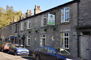
Nearest pubs – Vale Inn in the street, Dog & Partridge.
Council Ward – Central.
Historical interest
It seems the houses at the top of the street, Nos.1 – 9, were built by the Oliver family (owners of Waterhouse Mill). The following is an extract from the Land Registry:
The Leasehold land … of the … Title filed at the Registry and being 3 Adlington Road, Bollington SK10 5JT.
Short particulars of the lease(s) (or under-lease(s)) under which the land is held:
Date : 26 June 1860
Term : 999 years from 25 March 1859
Rent : £4.5s.0d [per annum]
Parties : (1) Thomas Oliver and William Creswick Lomas Oliver [brothers]
(2) Isaac Wright
NOTE: The lease comprises also 1, 5, 7 and 9 Adlington Road
Listed structures
See Listed Buildings page for the full list and notes regarding Listed, Article 4, and SPD properties.
The links on the structures are to the Historic England web site. Any links to local history pages are to this web site.
") |
(SPD) Bollington Conservative Club (now offices known as Adlington House); Mid 19th century Gothic. |